


Since the formation of the Moon, the Earth has been transformed from its droplet-like primordial form into its current state by the gravity ramp. The primordial continent once located at the South Pole was torn apart by equatorial currents, and the continents were distributed across the globe.
by Michael Klejna, still in progress, 09. Feb. 2024
Table of Contents
1. The history of the formation of continents based on the influence of the gravity ramp
To better imagine the effect of the gravity ramp while studying rigid world maps, one should envision it as a ship’s bow wave approximately five to ten latitudes wide. This ship travels from east to west around the equator once a day, crossing between the 28th parallels. Observing animated, rotating planetary models, one might liken it to a leg standing in a river, around which swirls form. Another visualization aid can be found at this link: the jsOrrery Orbit Viewer set to the view direction along the gravitational axis, starting from the center of the Moon directed towards the center of the Earth.
1.1. The continental drift from 300 million years ago to the present day
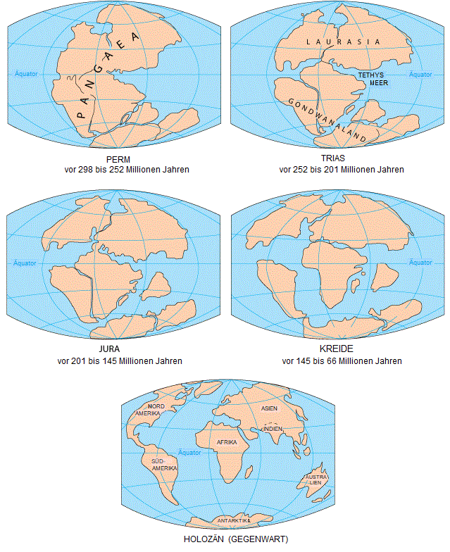
In the first image “PERM” we see the primordial continent Pangaea, which exhibits a notch to the east, created by the daily influence of the gravity ramp’s forces. Here, the continent must absorb the forces of the currents as it forms a natural dead end. Due to this dead end, crossing over the equator, and the associated weakening of equatorial currents, Pangaea’s position leads to the Karoo Ice Age (from 350 million years ago to 250 million years ago), see the timeline of glaciation.
Due to the forces generated by the gravity ramp, the continent fractures. In the second image “TRIAS” we observe fault lines north and south of the equator; the currents of the gravity ramp, which previously terminated in the notch, can now continue along these fault lines, marking the end of the ice age.
In the third image “JURA” we see the initial effects of counter-currents in the fault lines. India is undercut by the counter-current of the southern flow and moves northward, while Australia shows initial signs of movement eastward. To the north, the counter-current finds a point of attack at the emerging rift between Eurasia and North America. Meanwhile, the main currents widen the fault lines; to the south, the fault widens less, with the flow trying to orient back towards the equator, between South America and Africa.
In the fourth image ‘KREIDE’, the southern current finds its way back to the equator, the southern countercurrent continues to move Australia, India, and pushes Africa northward, the Middle East crosses the equator and begins to break away from Africa as a result. At the equator, the northern current is directed more northward by the returning southern current and manages to separate North America from Eurasia.
In the fifth image ‘HOLOZÄN’, we see Africa still trapped between the two southern and northern currents, however, the Middle East now crosses as an independent plate (the reason for the beginning of the ice age 34 million years ago) and the Horn of Africa (the reason for the beginning of the ice age 2.6 million years ago) crosses the equator, sealing drastic changes. Australia moves more northward than westward between the southern main current and its countercurrent. India has crossed the equator and is now pushed against Asia by the northern current. Antarctica moves back to its original position due to the dissolved connection to Australia, from which it was pulled by the connections to the drifting continents.
1.2. The continental drift from the formation of the Earth to 300 million years ago
Shortly after the formation of the Earth 4.5 billion years ago, the Moon also formed. Unlike today, its orbit around the Earth was much smaller, thus the common barycenter of the Earth and Moon was closer to the Earth’s core. The Earth rotated faster back then, and as it still does today, this self-rotation transferred to the orbital angular momentum of the Moon, enlarging its orbit and slowing down the rotation of the Earth. This process has been ongoing since the formation of the Moon.
As a result, the distance between the barycenter and the Earth’s core increases, enhancing the strength of the gravity ramp and its significance for continental drift. While a gravity ramp closer to the core mainly heats it and its effects are diffused on the long journey to the surface, one closer to the surface has a pronounced local character. Typically, this is equatorial, depending on the position of the gravitational axis, which lies between the 28th parallels in the Earth/Moon system. The effects of the gravity ramp have shaped the Earth since the formation of the Moon.
The only clues to the possible original form of the Earth are provided by our neighboring planets. Venus differs significantly from the Earth due to its parameters, while Mars exhibits very similar parameters. Mars has a droplet-like shape, and Venus also shows indications of a droplet-like form.
The Earth, in its assumed droplet-like original form, is subject to the forces of the gravity ramp. The gravity ramp’s center of force (barycenter) constantly moves, even today, towards the surface. As a result, rock is heated and melted. It becomes viscous, gains momentum, develops continuous currents, and both heat transfer (convection currents) and induction required for a magnetic field occur. Additionally, due to the heat, the Earth gains volume.
The chemical effects of the gravity ramp release light elements from the melting rock; these diffuse through the Earth’s mantle, creating an atmosphere. If this atmosphere becomes dense enough, water can form from the diffusing elements, and additionally the dense atmosphere rains down, forming oceans.
As sea levels rise, tides begin to corrode the primordial continent located at the South Pole. This continent resembles Pangaea from the first image “PERM” but is overall further south, with Africa as the center at the South Pole. The remaining continents surround Africa in a circle, with Eurasia adjacent to Africa in a clockwise direction compared to the image “PERM.”
At the connection between Eurasia and Africa, the primordial continent eventually breaks apart, and North America and Eurasia are drawn into the equatorial current. If the connections are strong enough, the mostly connected primordial continent is dragged along as a whole, while it continues to break apart at weaker points until it reaches the location depicted in the first image “PERM”, 90 degrees offset from the gravity ramp’s effect, weakening equatorial currents, leading to the Karoo Ice Age (from 350 million years ago to 250 million years ago), see the timeline of glaciation.
2. Conclusions
2.1. The future continental drift becomes calculable through the gravity ramp
Or more calculable, as the processes at the undersides of the continental plates will remain unseen. Nevertheless, based on the formation history, conclusions can now be drawn about their structure and future development. Additionally, the current movements of the continental plates need to be reevaluated.
2.2. The South Atlantic magnetic anomaly is related to continental drift
The gravity ramp heats the rock in the Earth’s interior and gives this viscous mass momentum. This momentum is very stable at high latitudes and deep in the southern latitudes, while it is partly chaotic at the equator due to the Moon’s constant crossing. This inductive process accounts for the equatorial part of the Earth’s magnetic field.
However, this process is influenced by the continental plates, as their position and depth can slow down or redirect the momentum necessary for the magnetic field.

The hot, malleable underside of the continental plates adapts to changes in flow dynamics faster than their rigid topside. The South Atlantic Magnetic Anomaly grows as the northern current weakens, with Africa being the reason. Since the Horn of Africa crossed the equator, not only one but both currents press Africa increasingly against Eurasia, in the future it will be either rotating clockwise over time or crumbling like Southeast Asia. There are already early signs: the Arabian Plate, the East African Rift, and Madagascar.
The northern flow channel between Africa and Eurasia is closing more and more, creating a backwater that directs and strengthens the southern flow more directly southward. The newly strengthened southern flow now has enough force to further erode the connection between South America and Antarctica, creating a new main flow channel south of South America.
Thus, the South Atlantic Magnetic Anomaly arises from the weakening of the northern current and the southward migration of the southern current. In the example of the gravitational ramp ring magnet model, the distance between the two rings increases here.
The forces of the gravitational ramp always act, and when they are not converted into torque and subsequently into flows and magnetic field strength, they act heat-generating in the form of friction, thus forming new flow channels.